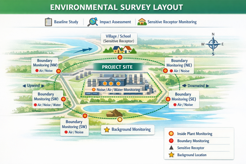
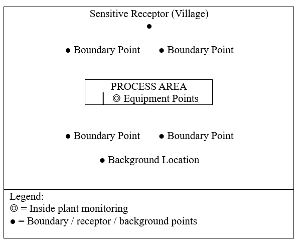
Environmental Survey Layout typically refers to the planned arrangement of monitoring/sampling locations across the project site and surroundings—ensuring proper coverage of environmental parameters (noise, air, water, soil, etc.).
✅1. Key Purpose of Environmental Survey Layout
- Establish baseline environmental conditions before project execution
- Identify sensitive receptors (residential areas, schools, hospitals)
- Define monitoring points across:
- Project boundary
- Core plant area
- Surrounding environment
✅2. Typical Environmental Survey Layout Components
A. Site Zoning (Layout Base)
- Start from:
- Project layout / plot plan
- Mark:
- Core process units
- Utilities & storage areas
- Roads and logistics
- Greenbelt / buffer zones
👉 Survey team must understand project layout and boundary before fixing monitoring locations
B. Monitoring Locations (Core Layout Design)
1. Inside Plant Area
- Near major equipment / emission sources
Example: Compressors, DG sets, Pumps
2. Boundary Monitoring Points
- Minimum 4–8 locations on plant boundary
- Cover:
- Upwind & downwind directions
- Nearest habitation side
👉 Boundary monitoring is critical for assessing environmental impact at interface zone.
- 3. Sensitive Receptors (Very Important)
- Identify external locations such as:
- Villages/residential areas
- Schools/hospitals
- Ecologically sensitive zones
👉 Must evaluate impact on sensitive receptors
4. Background / Control Locations
- Locations away from project influence
- Used for comparison with impacted areas
C. Survey Grid / Coverage Approach
- Radial layout (common for EIA)
- Grid-based (for complex industrial sites)
- Transect method (for large linear facilities)
✅3. Example Environmental Survey Layout (Conceptual)
✅4. Parameters Covered in Layout
Your layout should define sampling points for:
| Parameter | Layout Consideration |
| Noise | Equipment + Boundary + Sensitive receptors |
| Air Quality | Upwind / downwind / receptors |
| Water | Surface water bodies & discharge points |
| Soil | Near storage & waste areas |
| Ecology | Sensitive zones |
👉 Environmental monitoring programs are prepared during design phase to align with permits and ESIA requirements.
✅ 5. Important Practical Considerations
- Use site layout map + GPS for exact positioning
- Ensure accurate positioning of monitoring points
- Record environmental conditions during measurements
- Follow HSE safety & avoid hazardous zones
✅ 6. Deliverables of Environmental Survey Layout
- Environmental baseline survey map (in CAD / GIS)
- Monitoring location coordinates (UTM/Lat-Long)
- Survey methodology
- Compliance with EIA/permit requirements
- Survey report (e.g., Noise baseline report, AQ report)